

@qgis + #DroneDB #microtootorial
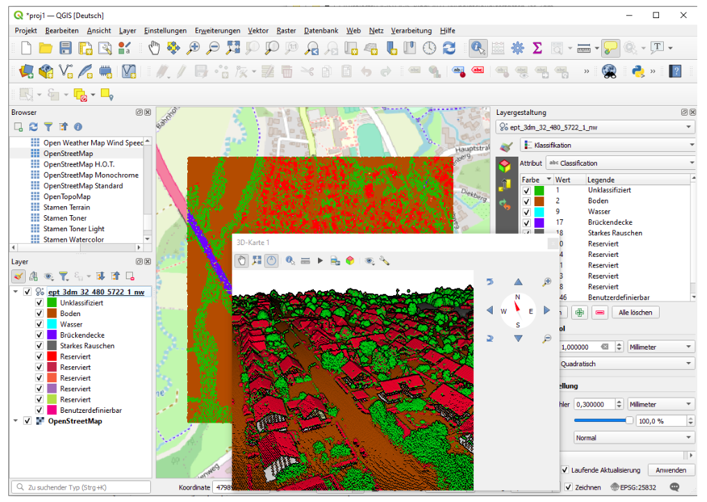
You have some drone images over a transect and want to get the approximate area covered [1]
Use #DroneDB CLI (https://docs.dronedb.app/docs/cli) to generate image footprints:
ddb info ./jpg/*.JPG -f geojson --geometry polygon -o footprints.geojson
Drop the footprint geojson into QGIS [2]. Dissolve them (Vector -> Geoprocessing Tools -> Dissolve) [3].
Reproject the result to a CRS in metres (eg UTM) and label with $area [4]
Done!
![[1] Drone images in a transect. The images must have GPS metadata - position and also orientation](https://cdn.masto.host/mapstodonspace/media_attachments/files/114/186/213/932/061/516/original/f352d8bf90b02501.png "[1] Drone images in a transect. The images must have GPS metadata - position and also orientation")
![[2] Image footprints from DroneDB CLI as black outlines. You will need to adjust the styling for this effect](https://cdn.masto.host/mapstodonspace/media_attachments/files/114/186/213/950/846/831/original/916300627ff1a988.png "[2] Image footprints from DroneDB CLI as black outlines. You will need to adjust the styling for this effect")
![[3] Dissolved image footprint polygons as a single purple polygon](https://cdn.masto.host/mapstodonspace/media_attachments/files/114/186/213/653/827/170/original/7a79af9053cf601b.png "[3] Dissolved image footprint polygons as a single purple polygon")
![[4] Dissolved footprints, reprojected to a CRS expressed in metres and labelled with the $area. The label field reads:
to_string(round($area,2)) || ' square metres'
...which rounds the $area attribute to 2 decimal places, converts it to a string, then concatenates it with the context string contaning units.](https://cdn.masto.host/mapstodonspace/media_attachments/files/114/186/213/705/299/604/original/2919095816a95f77.png "[4] Dissolved footprints, reprojected to a CRS expressed in metres and labelled with the $area. The label field reads:
to_string(round($area,2)) || ' square metres'
...which rounds the $area attribute to 2 decimal places, converts it to a string, then concatenates it with the context string contaning units.")

 𝗚𝗥𝗔𝗦𝗦 𝗚𝗜𝗦 𝟴.𝟰.𝟭 𝗶𝘀 𝗛𝗲𝗿𝗲!
 Visit
Visit  Download the latest version:


 Exciting news!
 The preliminary workshop schedule is live! Take a look at the schedule and start planning your FOSS4GE experience now.


 05.-06.03. Einführung in QGIS
 Reminder!
  There are only 2 weeks left to submit your proposals for the General Program!
  The deadline is on 16 February.
  We invite original submissions on software advancements, use cases, FOSS4G business models, technical details, policy making, etc.

 These workshops offer practical, hands-on sessions designed to help participants acquire new skills in using FOSS4G software.
 As we celebrate the beginning of 2025, let’s look forward to FOSS4GE, which will take place in just over six months! We’ll share more details as they become available, so keep an eye out!

 More info:
  This morning I led a workshop on